Weather and climate
 Weather change is not climate change
Did you know that most of the examples of climate change presented by the United Nations, politicians, government agencies and the news media are weather and not climate? This means that they are either don’t know the difference or they exploit the ignorance of the public. These examples are not climate change at all. I have pointed this out before.
Weather cycles in Australia
According to the Australian Bureau of Meteorology, the weather in Australia is influenced by at least four atmospheric cycles. These are the ENSO, the IOD, the SAM and the MJO.
El Niño – Southern Oscillation (ENSO)
The ENSO is the oscillation between El Niño and La Niña states in the Pacific region. El Niño (Appendix) typically produces drier seasons, and La Niña drives wetter years, but the influence of each event varies, particularly in conjunction with other weather influences. The ENSO is a complex give and take between the ocean and the atmosphere, which is controlled by multiple feedbacks.
Indian Ocean Dipole (IOD)
The IOD is defined by the difference in sea surface temperatures between the eastern and western tropical Indian Ocean. A negative phase typically sees above average winter-spring rainfall in Australia, while a positive phase brings drier than average seasons.
Southern Annual Mode (SAM)
The SAM refers to the north-south shift of rain-bearing westerly winds and weather systems in the Southern Ocean compared to the usual position.
Madden-Julian Oscillation (MJO)
The MJO is the major fluctuation in tropical weather on weekly to monthly timescales. It can be characterised as an eastward moving ‘pulse’ of cloud and rainfall near the equator that typically recurs every 30 to 60 days.
The Southern Oscillation Index (SOI)
The SOI gives an indication of the development and intensity of El Niño or La Niña events in the Pacific Ocean. Sustained negative values of the SOI lower than −7 often indicate El Niño episodes. These negative values are usually accompanied by sustained warming of the central and eastern tropical Pacific Ocean, a decrease in the strength of the Pacific Trade Winds, and a reduction in winter and spring rainfall over much of eastern Australia and the Top End. During an El Niño, the ocean releases heat into the atmosphere. That’s why El Niño years are usually among the hottest on record.
Sustained positive values of the SOI greater than +7 are typical of a La Niña episode. They are associated with stronger Pacific trade winds and warmer sea temperatures to the north of Australia. Waters in the central and eastern tropical Pacific Ocean become cooler during this time. Together these give an increased probability that eastern and northern Australia will be wetter than normal.
Global weather – temperature
Satellite temperature measurements are inferences of the temperature of the atmosphere at various altitudes as well as sea and land surface temperatures obtained from radiometric measurements by satellites. These satellite measurements avoid the interference of the urban heat island on land-based temperature measurements.
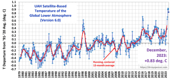
The monthly average temperature of the global lower atmosphere as measured by satellites is graphed from 1979 to 2023 below (Spencer, 2024). This shows a warming of about 0.55 deg C over 40 years (1980-2020). There are peaks and troughs imposed on the overall trend. These peaks and troughs are caused by various weather patterns.

The temperature peaks are listed below together with the ENSO status associated with them, which was determined from the Oceanic Niño Index (ONI) (NOAA, 2024).
1980-81 La Niña
1983-84 very Strong El Niño
1987-88 Strong El Niño
1991 Strong El Niño
1998-99 (major peak) very Strong El Niño
2010-11 La Niña
2016 (major peak) very Strong El Niño
2020 La Niña
2024 (major peak) strong El Niño
Each of the three major temperature peaks were associated with strong or very strong El Niños. These are up to +(0.6-0.7) deg C above the normal monthly average temperature. This means that El Niños could cause peaks of several degrees C above normal for maximum daily temperatures above land surfaces.
The other temperature peaks can be associated with strong or very strong El Niños or with a La Niña.
The strong and very strong El Niños are listed below together with the temperature status associated with them:
!982-83 Peak
1987-88 Peak
1991-92 Valley
1997-98 Major peak
2015-16 Major peak
2023-24 Major peak
It looks as though the temperature of the lower atmosphere increases if there is a strong or very strong El Niño. But it can also increase sometimes if there is a La Niña. And it was a valley instead of a peak in 1991-02. 1992 was the coldest year of the 1990s despite being an El Niño year because of the cooling influence of the eruption of Mount Pinatubo in June 1991.
So, the relationship between the ENSO and global temperatures is complex. It’s impact can be moderated by other atmospheric cycles and by volcanoes. In practice, when seasonal weather forecasts that have been based on ENSO predictions are incorrect, another one of the weather cycles is invoked to explain the discrepancy. This is usually a hindcast and not a forecast!
 Global climate – temperature
The World Meteorological Organization (WMO) uses a 30-year period to determine the average climate. So climate is defined as the weather that occurs over a 30-year period. Originally this was 1901-30, 1931-60, 1961-90. Since 1956 the WMO recommended that the 30-year climate normals be updated every 10 years.
The monthly average temperature of the global lower atmosphere as measured by satellites is only available for a period of 44 years. The usual period for averaging climate variables is 30 years. So, in this case we will determine 20-year averages instead.
 The increase in the 20-year mean temperature between 1980-1999 and 2000-2019 was 0.255 deg C. And the minimum monthly temperature increased by 0.25 deg C and the maximum monthly temperature increased by 0.09 deg C.
Conclusions
Weather is a complex interaction of atmospheric cycles which are difficult to forecast. But as climate is weather over considerably longer periods of time, climate is also complex and poorly understood. As weather forecasts are not always reliable, so climate forecasts will be even more unreliable and uncertain.
An assessment of climate change using satellite data showed a warming of 0.25 deg C between two recent 20-year periods. How much of this is due to natural variability and how much is due to human influences? I think that this is still an open question despite the propaganda attributing it all to human influences. According to Spencer, “The reasons for small, long-term changes in the climate system are still extremely uncertain”.
Appendix: El Niño
The term El Niño refers to “the Christ child”, Jesus, because periodic warming in the Pacific near South America is usually noticed around Christmas.
La Niña (“The Girl” in Spanish) is the colder counterpart of El Niño.
References:
BOM, 2024, Climate drivers in the Pacific, Indian and Southern oceans and the Tropics.
NOAA, 2024, Cold & Warm Episodes by Season, National Weather Service.
Spencer R, 2024, Satellite based global temperatures
Also see: The real climate change
A robust climate?
A reminder for the WMO – Weather is not climate
A reminder for the BOM – Weather is not climate
Written, January 2024


Leave a comment